Rabies is a zoonotic disease that is capable of infecting a wide range of mammalian hosts. After initial infection, the virus attacks the central nervous system and generally proves to be fatal for the host mammal (Government of Canada, 2020). The virus is highly contagious and is capable of spreading throughout local mammal populations in very little time at all. As such, ongoing rabies surveillance and vaccination initiatives are absolutely critical for stemming outbreaks of the virus in wild populations of vector species that are capable of transmitting rabies to humans (Government of Canada, 2020).
Due to the ongoing threat that rabies poses throughout Canada and the United States, the 2008 North American Rabies Management Plan (NARMP) was created as a joint effort to cooperatively monitor the spread of the virus and develop related management strategies in both countries (Tataryn & Buck, 2016). The formation such this plan solidifies the idea that rabies is a shared responsibility of both nations and that a detailed collaborative framework is required to deal with the issue (Tataryn & Buck, 2016).
While the NARMP has laid the foundation for collaborative rabies management initiatives in the modern era, the United States has had tremendous success within their own borders when it comes to rabies surveillance, mapping, and oral bait distribution. In fact, they have developed an in-depth GIS application for that very purpose. This program is called RabID, and it is noted as being one of the most useful computer database applications when it comes to tracking rabies and oral vaccine deployment initiatives.
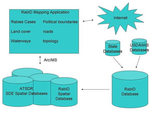
Essentially, RabID is a GIS-based rabies surveillance record and Internet mapping program. This password-protected application acts as a centralized database for information gathered by federal, state, and local government bodies that deal with the observation of rabies (Blanton, et al., 2006). Upon the submission of geo-referenced data to the mapping application database, authorized users can create their own regional maps – as displayed in Figure 1 – or update existing data records for others to access. This program is not accessible by the general public, but the maps may be acquired for demonstrative and educational purposes (Blanton, et al., 2006).

One of the most useful things about the RabID surveillance system is that it was developed from existing technology and can easily be reprogrammed to monitor the development of other issues, zoonotic or otherwise. Under these specific conditions, the usefulness of similar geographically-based, Internet accessible surveillance programs can be intensely exploited and refined to monitor particular areas of human interest (Blanton, et al., 2006). Some of these possibilities include tracking outbreaks of White-nose Syndrome in bats, Viral Hemorrhagic Septicemia (VHS) in fish, and Avian Botulism in waterfowl, all of which are serious problems that Fish and Wildlife technicians may encounter in the field. This technology could even be used for more relevant anthropological purposes, such as monitoring the spread of COVID-19 cases within a country, province, or state. In turn, this may offer valuable insight into the movement patterns and developmental time frames of some of the world’s deadliest diseases.
One of the primary drawbacks of RabID is that it is only accessible by specific government agencies that are directly involved with the study of rabies. While this may seem useful for maintaining high data accuracy, there is the possibility that program funding may be cut, which would cause the system to fall into disuse. Database accuracy depends exclusively on the data supplied to it by the government activities and laboratory tests. As such, if no tests are being performed, no data updates will be entered. The status of an outbreak can change rapidly, and if proper vaccination procedures are to work, the data that they rely on must be accurate and up-to-date.
Rabies is a serious issue that continues to pose a risk to both humans and wild mammals. As such, GIS-based programs like RabID are on the forefront of rabies surveillance and are often utilized by field technicians to develop vaccine distribution strategies. Many graduating Fish and Wildlife Technician students may find themselves using the results of similar programs throughout the course of their careers.
References
Blanton, J. D., Manangan, A., Manangan, J., Hanlon, C. A., Slate, D., & Rupprecht, C. E. (2006, November 01). Development of a GIS-based, real-time internet mapping tool for rabies surveillance. Retrieved from BioMed Central: https://ij-healthgeographics.biomedcentral.com/articles/10.1186/1476-072X-5-47#citeas
BioMed Central. (2006). RabID database [diagram]. Retrieved from: https://ij- healthgeographics.biomedcentral.com/articles/10.1186/1476-072X-5-47#citeas
BioMed Central. (2006). Rabies tracking [map]. Retrieved from: https://ij- healthgeographics.biomedcentral.com/articles/10.1186/1476-072X-5-47#citeas
Government of Canada. (2020, March 27). Rabies in Canada. Retrieved from Canada.ca: https://www.inspection.gc.ca/animal-health/terrestrial-animals/diseases/reportable/rabies/rabies-in-canada/eng/1356156989919/1356157139999
Tataryn, J., & Buck, P. A. (2016, June 2). The Canadian rabies management plan: An integrated approach to the coordination of rabies activities in Canada. Retrieved from Canada.ca: https://www.canada.ca/en/public-health/services/reports-publications/canada-communicable-disease-report-ccdr/monthly-issue/2016-42/ccdr-volume-42-6-june-2-2016/ccdr-volume-42-6-june-2-2016-rabies-4.html
*NOTE* Despite my best efforts, my references would not properly indent, as per APA standards.